Dowagiac Municipal Airport (C91)
- C91 - Dowagiac Municipal Airport | SkyVector
- Dowagiac Airport Chart Supplement
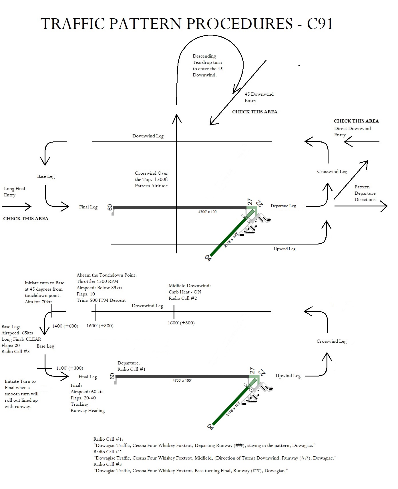
- Dowagiac Airport C91 Pattern
Location: 1 NW of Dowagiac, Michigan
Coordinates: N41º59.58´ W86º07.70´
UTC Offset: UTC–5 (–4DT)
Traffic Pattern Altitude: 1547 ft (800 ft AGL)
NOTAM File: LAN
Runway Information
- RWY 09–27:
- Length: 4700 x 100 ft (Asphalt)
- Surface: Asphalt
- Slope: S–30, D–60
- Lighting: MIRL (Medium Intensity Runway Lights)
- RWY 09:
- REIL (Runway End Identifier Lights)
- PAPI(P4L)—GA 3.0º, Threshold Crossing Height (TCH) 35 ft
- Obstacles: Crops
- RWY 27:
- REIL
- PAPI(P4L)—GA 3.0º, TCH 35 ft
- Obstacles: Trees
- Right traffic pattern
- RWY 04–22:
- Length: 2176 x 100 ft (Turf)
- RWY 04:
- Obstacles: Trees
- RWY 22:
- Displaced threshold 388 ft
- Obstacles: Tree
- Right traffic pattern
Services
- Fuel: 100LL available
- Lighting Activation:
- MIRL Rwy 09–27
- PAPI Rwy 09 and 27
- REIL Rwy 09 and 27—Activate via CTAF
Airport Remarks
- Unattended airport
- Wildlife: Deer and birds on and around the airport
- Remote Control Aircraft (RC) operations on the east side of Rwy 04–22
- Self-service fuel available 24 hours
- Administration building access instructions: depress V, then III–II simultaneously, then I
- Rwy 04–22 and displaced threshold marked with 3 ft yellow cones
Communications
- CTAF/UNICOM: 122.8
- KELLER RCO: 122.1R, 116.6T (LANSING RADIO)
- South Bend Approach/Departure Control: 118.55 (1030–0500Z‡ Sun–Fri, 1030–0445Z‡ Sat), other times contact Chicago Center on 127.55
- Clearance Delivery Phone:
- South Bend Approach: 574-251-2609
- Chicago ARTCC: 630-906-8921 (when South Bend Approach is closed)
Radio Aids to Navigation
- Keeler (L) VOR/DME: 116.6 ELX (Channel 113)
- Location: N42º08.66´ W86º07.36´
- Distance: 182º, 9.1 NM from the airport
- Elevation: 794 ft
- DME Unusable: 155º–010º beyond 30 NM below 3,500 ft